

Yesterday, Keefy, Jazz the pooch and I had a lovely walk in beautiful Norfolk countryside.
Saxlingham Nethergate was our destination, which is just under 10 miles south of Norwich.

We’d read about the walk on the BBC Walks page so packed a small picnic, loaded Jazz into the boot and set off, arriving at Saxlingham Nethergate just after 12:00.
As soon as you drive into the village, you get a sense of why the BBC call this one of the prettiest villages in Norfolk.

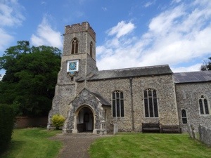
The walk starts at the car park at the recreation ground, where you can park for free. It takes you towards the very pretty church, which is on a tiny little village green with a magnificent Elizabethan manor on one side.
You walk through the grounds of the churchyard and through a little gate and into the open vistas of the beautiful countryside, with fields of barley and wheat rolling in front of you.
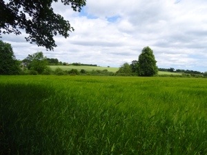
It really is beautiful, and you get to enjoy these views through the majority of the walk as most of the well kept paths skirt around field edges, every now and again dipping you into a woodland area.


There’s only a very small section of road to walk on on this 5 mile stroll, so you can really relax, take in the rolling scenery and enjoy the wild flowers lining the paths. It would be a good walk to do in the autumn as we passed loads of blackberry brambles, in full flower. I was hoping to collect some elderflower to make some cordial, but I think we’re a bit late as it seemed to be looking worse for wear. Maybe next year. The fields were looking healthy though and it’s always a joy to see poppies.


Towards the end of the walk you walk round a field full of horses, who seemed particularly interested in Jazz!

They followed us all the way around the perimeter!
Near our return to the car park, we realised that we hadn’t eaten our picnic, so we took a welcome break in the last field to enjoy our rolls!

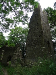
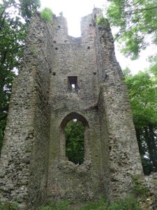
Just before reaching the car park, the path leads you into the woodland where the remains of St Mary’s church lie, which was abandoned in 1688.
We enjoyed the walk, it took us 1hr 45 to complete, which we were impressed with. We found the written instructions very easy to follow and mainly accurate, but we would recommend you make sure you have an ordnance survey map for the area, or like us- a memory map gps device, to accompany you.
